
Guilin + Yangshuo + Longji Rice Terraces 5-Day 4-Night Route inspiration
Here are the reasons to visit Guilin:
- Guilin is internationally recognized as a top tourist destination. It has been blessed with picturesque landscapes that have made it famous through the ages. With its gentle river bends, interconnected lakes, and the scattered verdant hills inside and outside the city, Guilin has gained worldwide renown.
- Guilin’s appeal lies in its karst hills, waterways and surrounding countryside. Visibility, rainfall and air quality vary, so check the forecast rather than expect clear skies every day.
- The city of Guilin is shaded by green trees, with osmanthus trees lining the streets and alleys. When autumn arrives, the city is filled with the rich fragrance of osmanthus, which is refreshing and not overly sweet.
-
Guilin does not have the hustle and bustle of Beijing, the noise of Shanghai, or the leisurely pace of Chengdu. Guilin is like a tuberose flower that blooms at night, exuding a quiet elegance and nobility.

Itinerary
Day 1 — Arrive in Guilin & explore the city
Full itinerary heading
Day 1 — Departure Place - Guilin: independent sightseeing options, Dongxi Alley → Sun and Moon Pagodas → Liangjiang Si Hu (Two Rivers and Four Lakes) → Zhengyang Pedestrian Street → Rongshu and Shanhu Lake Scenic Area.
declarationGuilin (Standard Zhuang: Gveilinz), formerly romanized as Kweilin, is a prefecture-level city in the northeast of China’s Guangxi Zhuang Autonomous Region. It is situated on the west bank of the Li River and borders Hunan to the north. Its name means “forest of sweet osmanthus”, owing to the large number of fragrant sweet osmanthus trees located in the region. The city has long been renowned for its scenery of karst topography.
Guilin is one of China’s most popular tourist destinations, and the epithet “By water, by mountains, most lovely, Guilin” (山水甲天下) is often associated with the city. The State Council of China has designated Guilin a National Famous Historical and Cultural City, doing so in the first edition of the list.
Day 2 — Longji Rice Terraces & local villages
Original itinerary heading
Day 2 — Longji Rice Terraces Scenic Area — Huangluo Yao Village & Long Hair Village — Ping'an Zhuang Village / Jinkeng Dash Village (Golden Buddha Top for a 270-degree view of the terraced fields) / Hongxi Waterfall.
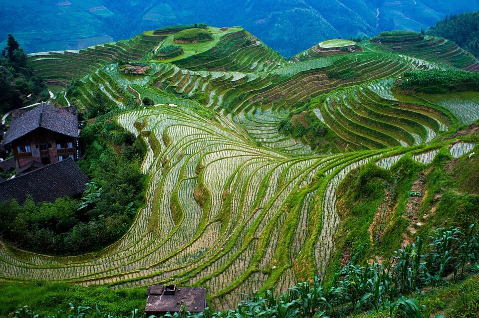
The Longji Rice Terraces (“Dragon’s Backbone”) (simplified Chinese: 龙脊梯田; traditional Chinese: 龍脊梯田; pinyin: lóngjǐ tītián), also called the Longsheng Rice Terraces (“Dragon’s Victory”) (simplified Chinese: 龙胜梯田; traditional Chinese: 龍勝梯田; pinyin: lóngshèng tītián), are located in the town of Longji in Longsheng Various Nationalities Autonomous County, about 100 kilometres (62 mi) from Guilin, China. Planning note: Ping’an and Jinkeng are alternative terrace bases, not a promise to complete both plus the waterfall. Choose one area and confirm local transfers; allow extra time for uphill paths.
The terraced fields are built along the slope winding from the riverside up to the mountain top, between 600 and 800 metres (2,000 and 2,600 ft) above sea level. A coiling terrace line that starts from the mountain foot up to the mountain top divides the mountain into layers of water in spring, layers of green rice shoots in summer, layers of rice in fall, and layers of frost in winter. The terraced fields were mostly built about 650 years ago.
Longji (Dragon’s Backbone) Terraced Rice Fields received their name because the rice terraces resemble a dragon’s scales, while the summit of the mountain range looks like the backbone of the dragon.
The paddies change from water-filled terraces to green growth and harvest colours through the agricultural year. The exact irrigation and planting dates vary by village and season; check locally before planning around a particular appearance.
Day 3 — Li River, Ten-Mile Gallery & Yulong River
Original itinerary heading
Day 3 — Guilin - Cruise on the Li River — Cycling through the Ten-Mile Gallery — Yulong River Rafting.
The Li River or Li Jiang (Chinese: 漓江; pinyin: Lí Jiāng) is the name for the upper reaches of the Gui River in northeastern Guangxi, China. It is part of the Xijiang River system in the Pearl River basin, flowing 164 kilometres (102 mi) from Xing’an County to Pingle County. Planning note: A full Li River cruise plus cycling and Yulong rafting is an ambitious combination. Put the confirmed cruise first and move cycling or rafting to another day. Raft routes and age/height/safety rules must be checked with the operator.
Tourist rafting boats cruise from Yangshuo County, on the Li River
The upper course of the Li River is connected by an ancient Lingqu canal with the Xiang River, which flows north into the Yangtze; this in the past made the Li and Gui Rivers part of a highly important waterway connecting the Yangtze valley with the Pearl delta.
The 439-kilometre (273 mi) course of the Li and Gui Rivers is flanked by green hills. Cormorant fishing is often associated with the Lijiang.
Cruises on the Li are famous, attracting millions of visitors per year.
Day 4 — Fuli Bridge, Xianggong Mountain & Yangshuo
Original itinerary heading
Day 4 — Yangshuo - Fuli Bridge — Xianggong Mountain — Yinzi Rock / Ruyi Peak / Moon Water Cave Exploration.
Yangshuo County (simplified Chinese: 阳朔县; traditional Chinese: 陽朔縣; pinyin: Yángshuò Xiàn) is a county under the jurisdiction of Guilin City, in the northeast of Guangxi, China. Planning note: The slash-separated caves and peaks are choices. Pick one additional attraction around the bridge or mountain visit rather than trying to visit all of them.
In the 1980s, the county became popular with foreign visitors engaging in backpacker tourism, and organized tours began by the late 1990s. At the time, domestic tourists represented only a small fraction of the county’s visitors, but they outnumbered foreign tourists by 2005. Today, the county is a resort destination for both domestic and foreign travelers.
The history of West Street dates back over 1,400 years ago. Since the street is popular with locals and foreigners alike, signs are written in both Chinese and English. Some tourism businesses offer English assistance, but keep Chinese place names and offline translation available.
The Yangshuo region has numerous locations for climbing, and they are accessible by bicycle, public bus, or taxi van. The most famous of these crags is Moon Hill, which has several lines graded 5.13 in the Yosemite scale. Other crags of note include Low Mountain, Twin Gates, Baby Frog, the Egg, Bamboo Grove, and Wine Bottle Cliff.
Day 5 — Elephant Trunk Hill & departure
Original itinerary heading
Day 5 — Yangshuo - Guilin Elephant Trunk Hill - Return Trip.
The Elephant Trunk Hill (Chinese: 象鼻山; pinyin: Xiàngbí Shān) is a hill, landmark and tourist attraction in Guilin, Guangxi, China.
Elephant Trunk Hill is the symbol of the city of Guilin. It got its name because it looks like an elephant drinking water. The round opening that would be under the elephant’s trunk is known as Water-Moon Cave because at night the reflection of the moon can be seen through the arch and it looks as if it is under the water and floating on the surface of the water at the same time. Elephant Trunk Hill and Water-Moon Cave are located at the confluence of the Taohua River and the Lijiang River.
FAQs
1. Q: Are there English-speaking guides available for the Li River cruises?
A: In popular tourist destinations like Guilin, it is possible to find English-speaking guides for Li River cruises. You can inquire at the tourist centers or when booking the cruise.
2. Q: When were the terraced fields mostly built?
A: The terraced fields were mostly built about 650 years ago.
3. Q: Is it safe to climb in the Yangshuo climbing areas?
4. Q: Where is Elephant Trunk Hill located?
A: Elephant Trunk Hill and Water-Moon Cave are located at the confluence of the Taohua River and the Lijiang River.
5. Q: Can I see the Elephant Trunk Hill at night?
A: Check the scenic area’s current evening opening and lighting notices. Viewing a lit landmark from a public area does not imply that the park or Water-Moon Cave is open after dark.
6. Q: What entry permission does this route require?[3]
A: Check every stop against the NIA permitted-area table; a short itinerary alone does not qualify. For 240-hour transit, eligibility depends on your passport, designated port, confirmed onward travel to a third country or region, and the stay granted. Verify the current NIA rules before booking; otherwise use another valid entry/stay basis.[4]
Before you make arrangements
Current cruise piers, water-level restrictions, raft rules and Longji local transport remain date-specific checks. No current all-in ticket price or harvest calendar is asserted.
Notes & sources
These notes support the specific corrections above. They do not mean that every sentence, future opening time or individual eligibility has been verified.
Correction notes and source scope
Remove unsupported sale/group-departure implication while preserving destination names and original duration.
Editorial correction; no new factual-verification date claimed.Clarify that unstructured time does not mean attraction admission or purchases are free.
Editorial correction; no new factual-verification date claimed.Replace obsolete 144-hour FAQ with current entry-permission question.
NIA — current visa-free transit policy and permitted-area tableSource checked 2026-10-31Remove blanket 144-hour entitlement and obsolete 2024 guide reference; apply current NIA conditions and route-specific geographical limits.
NIA — current visa-free transit policy and permitted-area tableSource checked 2026-10-31Remove unsupported pollution-free and permanent sunshine claims.
Editorial correction; no new factual-verification date claimed.Replace fixed early-June agricultural timetable with seasonal variability.
Editorial correction; no new factual-verification date claimed.Remove universal language expectation and unsupported comparison.
Editorial correction; no new factual-verification date claimed.Keep original destination narrative; add specific pacing/access constraint for this day.
Editorial correction; no new factual-verification date claimed.Keep original destination narrative; add specific pacing/access constraint for this day.
Editorial correction; no new factual-verification date claimed.Keep original destination narrative; add specific pacing/access constraint for this day.
Editorial correction; no new factual-verification date claimed.Remove unverified night-opening and guaranteed illumination implication.
Editorial correction; no new factual-verification date claimed.Remove generic safety assurance for technical climbing; retain practical choice.
Editorial correction; no new factual-verification date claimed.
- NIA — current visa-free transit policy and permitted-area table
31 route geographic-scope screenings; image table independently viewed locally. Reopened in this review.
Checked 2026-10-31 - UNESCO — South China Karst
Karst landscape context for Guangxi, Guizhou and Chongqing; not operating conditions. Evidence inherited from the 29 October audit; not a fresh operating-calendar check.
Checked 2026-10-29